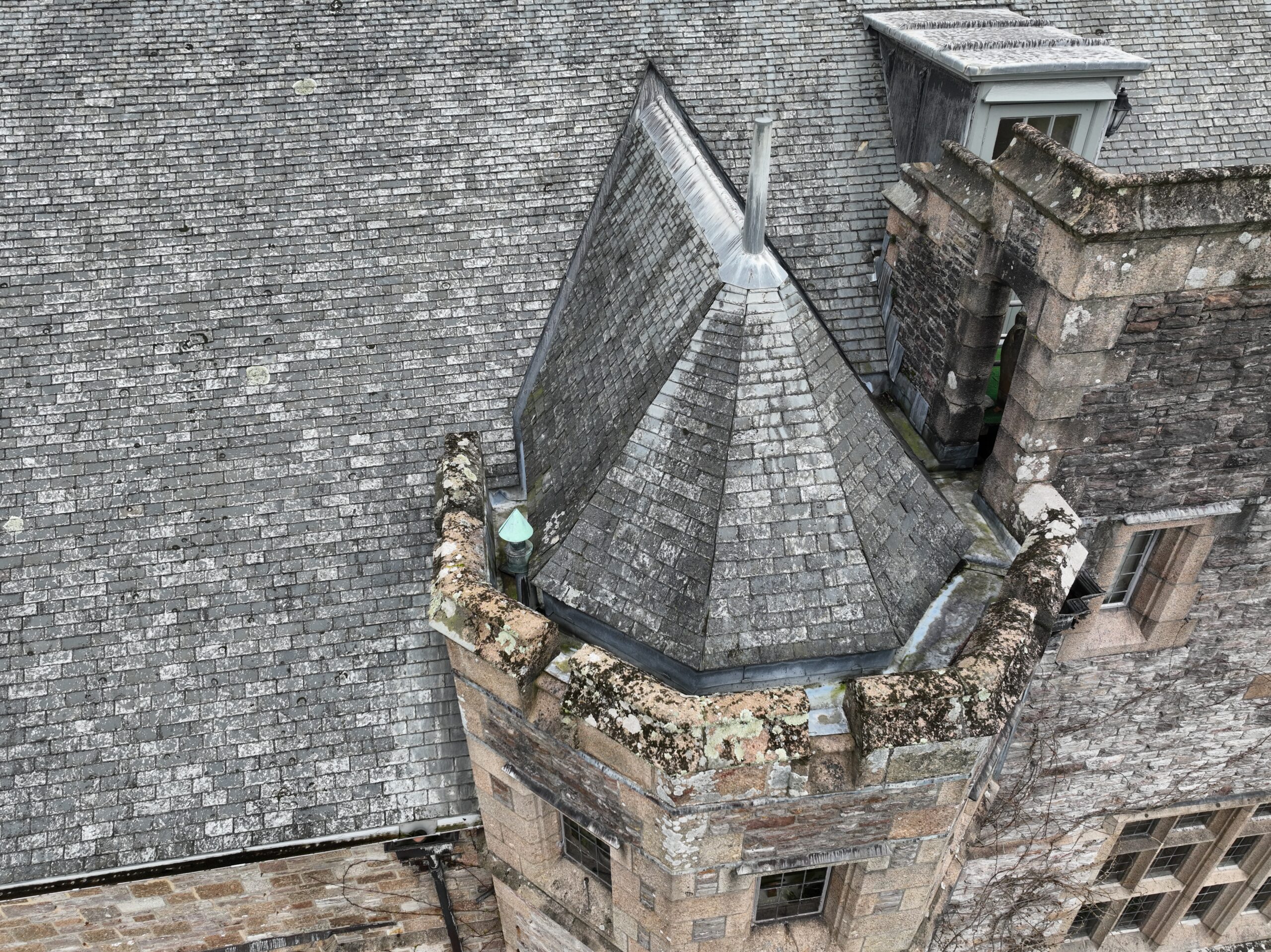
Some areas are difficult to inspect from the ground. Roofs, gutters, chimneys, high elevations and hard-to-reach structures often need a clearer view before anyone can make a practical decision.
That is where drone surveys can help.
At Different View, we use drone filming and aerial photography to give clients a safer first look at roofs and property features. The aim is simple: capture clear visual information from above so property owners, contractors, surveyors and facilities teams can understand what may need attention.
A drone does not replace every type of physical inspection. But it can make the first stage safer, clearer and more efficient.
Why access matters
Traditional roof inspections can involve ladders, scaffolding, towers or other access equipment. In some cases, that may still be necessary. But it does not always need to be the first step.
A drone can capture images and video from multiple angles while the operator remains safely on the ground. This helps clients review visible areas before deciding whether they need further investigation, repair work or specialist access.
For properties in Plymouth, this can be useful when access is awkward, the building is exposed, or the client needs quick visual evidence before planning the next stage.
Our dedicated drone roof survey Plymouth page explains how we use aerial footage to support safer roof inspections in the local area.
What a drone can help show
A drone survey gives clients a clearer view of areas that are hard to assess from ground level.
Depending on the property and conditions, we can help capture visible information such as:
- Roof condition
- Broken or slipped tiles
- Blocked gutters
- Chimney condition
- Flat roof areas
- Weathering
- Storm damage
- Access issues
- Hard-to-reach elevations
- General property condition from above
The footage gives clients something practical to review and share. It can help conversations with roofers, contractors, insurers, landlords, tenants or maintenance teams.
A safer way to start
Safety sits at the centre of professional drone work.
By using a drone for the first visual check, we can reduce the need for unnecessary work at height during the early stage. Clients can see what is visible from above, identify areas of concern and then decide what type of follow-up is needed.
This approach works well when you want to understand the situation before committing to scaffolding, access equipment or a full physical inspection.
It also creates a useful visual record, which can support maintenance planning or future comparison.
Useful for Plymouth properties
Plymouth properties often face coastal weather, strong winds, salt air and changing conditions. Roofs, gutters and external features can show wear over time, especially on exposed sites.
A drone survey can help homeowners, landlords, commercial property owners and facilities managers inspect visible areas after bad weather, before maintenance work, during property checks or as part of wider site documentation.
For wider aerial filming and property-related visual content, our drone videography Plymouth page shows how we use drone footage to capture buildings, sites and locations clearly.
Clear footage makes decisions easier
A good roof survey should make the next step easier to understand.
We capture footage and images with a purpose in mind. That means we focus on the areas the client needs to see, not just general aerial shots of the building.
Clear visuals can help a contractor understand the location of a visible issue. They can help a landlord explain a problem. They can help a property owner decide whether further investigation is needed.
The value comes from clarity.
Planning still matters
Even a short drone survey needs proper planning.
Before we fly, we consider the property, surrounding buildings, trees, public areas, roads, weather, take-off points and any site-specific risks. We also look at what the client needs to understand so we can capture the right areas properly.
Our equipment supports a range of aerial filming and photography work, from roof surveys and property content to maritime, FPV and ground production. You can read more about our kit and how we use it on our production equipment page.
A practical first step before further work
Drone roof surveys work best when clients need a practical first look.
They can help answer questions such as:
- Can we see any visible damage?
- Is the guttering blocked?
- Does the roof need closer inspection?
- Where is the issue located?
- Is access likely to be difficult?
- What information does a contractor need before visiting?
The footage helps people make better-informed decisions. It also reduces guesswork before anyone works at height.
Drone-led inspections with clear visual output
At Different View, we plan drone work carefully and capture footage with a clear purpose. For roof surveys, that means giving clients useful visual information from above, while keeping the process safe, controlled and efficient.
If you need a clearer view of a roof or hard-to-reach area in Plymouth, we can help you capture the footage you need before deciding on the next step.
Visit our drone roof survey Plymouth page or send us the project details to discuss what you need to inspect.


